


In September 2025 I joined a Journeys by Rail tour of the National Parks of the Colorado Plateau. I left Union Station in Chicago and traveled on Amtrak's California Zephyr to Grand Junction, Colorado, where I left the train and boarded a tour bus with a tour guide, a very no-nonsense bus driver, and 34 other people. We were to explore many places on the Colorado Plateau, a vast uplifted high desert area with stunning canyons, mesas, buttes and dramatic rock formations. The area consists of many layers of sedimentary rock sculpted over millenia by the Colorado River and many other natural forces. The area is arid (10 inches of rain or less annually) and makes up parts of 4 states: CO, AZ, NM, and UT. It also is the site of some of the best National Parks in the U.S. In order, this is what we witnessed and explored during the next 9 days: Arches NP, a boat trip up the Colorado River, Capitol Reef NP, ancient petroglyphs representative of Fremont Rock Art (450 - 1300 AD), Escalante Grand Staircase National Monument, Bryce National Park, Zion National Park, a visit to Glen Canyon Dam (one of the largest of the 15 dams on the main route of the Colorado River) and a boat ride on Lake Powell, and then lastly two wonderful days at one of the natural wonders of the world -- Grand Canyon National Park. Here are some photos of what was a wonderful trip.
 |
The Zephyr passing through the Rocky Mts alongside the Colorado River |
 |
Double Arch at Arches NP |
 |
Capitol Reef NP |
 |
Castle Rock at Capitol Reef NP |
 |
| Escalante Grand Staircase National Monument |

 |
Uinta chipmunk at Bryce |
 |
Bryce |
 |
Zion NP |
 |
Glen Canyon Dam on the Colorado River |
 |
Tour Boat for the cruise on Lake Powell |
 |
Grand Canyon NP |
 |
The start of the Bright Angel Trail at Grand Canyou |
Whenever I visit the UK I usually manage to visit one or more of the many stately homes and manors that were once lived in (and in some cases still are) by England's rich and famous. Over the years I have visited many, and during a recent visit to England in October 2024 I was able to visit 3 more of the many stately homes in the country. Many of these homes are now owned or managed by the National Trust and many are not easily accessible by train or other forms of public transport. Usually they are visited by people with their private cars and thanks to a good English friend, Clive Renton, I was able to visit 3 of these opulent homes during my recent visit. Welcome to Dyrham House, a baroque English country house in an ancient deer park near the village of Dyrham in county Gloucestershire, England. The house has an attached orangery and stable block and is listed on the National Register of Historic Parks and Gardens. The house and grounds have been the location of many BBC productions and movies, includng "The Remains of the Day", "Sanditon", "Sense and Sensibility", "Tess of the d'Urbavilles" and others. In terms of a very brief history, in 1689 a man by the name of William Blathwayt inherited a run-down Tudor house at the same time that he married an heiress. He then began transforming the house into a late 17th Century stately home. Blathwayt amassed a fortune from his involvement with the slave trade in the Caribbean. He was well known by the reigning monarchs of his time and held the post of Secretary of War for Queen Anne. The home and grounds are magnificent to witness. Blathwayt once anticipated a visit by Queen Anne and made a special bed for her, but she changed her mind and never came. He built a "best" staircase leading to the best rooms on the second floor that was made entirely of red cedar from North America, an extraordinary and unusual use of American wood in an English home and an evidence of his influence and connections with America. Another staircase in the home -- the Old Staircase -- is made of black walnut from Virginia. The Balcony Room, a luxurious upstairs reception room, has two painted stands depicting enchained African slaves. In the downstairs "Bells Passage" there are 30 bells connected to 30 different rooms in the home. Each bell rang with a different tome that the servants were able to recognize. The bells are more than 150 years old.
 |
| Dyrham House |
 |
| 17th Century Greenhouse |
 |
| View of house from the Water Gardens |
 |
| Portrait of William Blathwayt |
 |
| Bed Chamber made specifically for Queen Anne's visit, but she never showed up. |
 |
| "Best" Staircase |
 |
| Old Staircase |
 |
| Balcony Room |
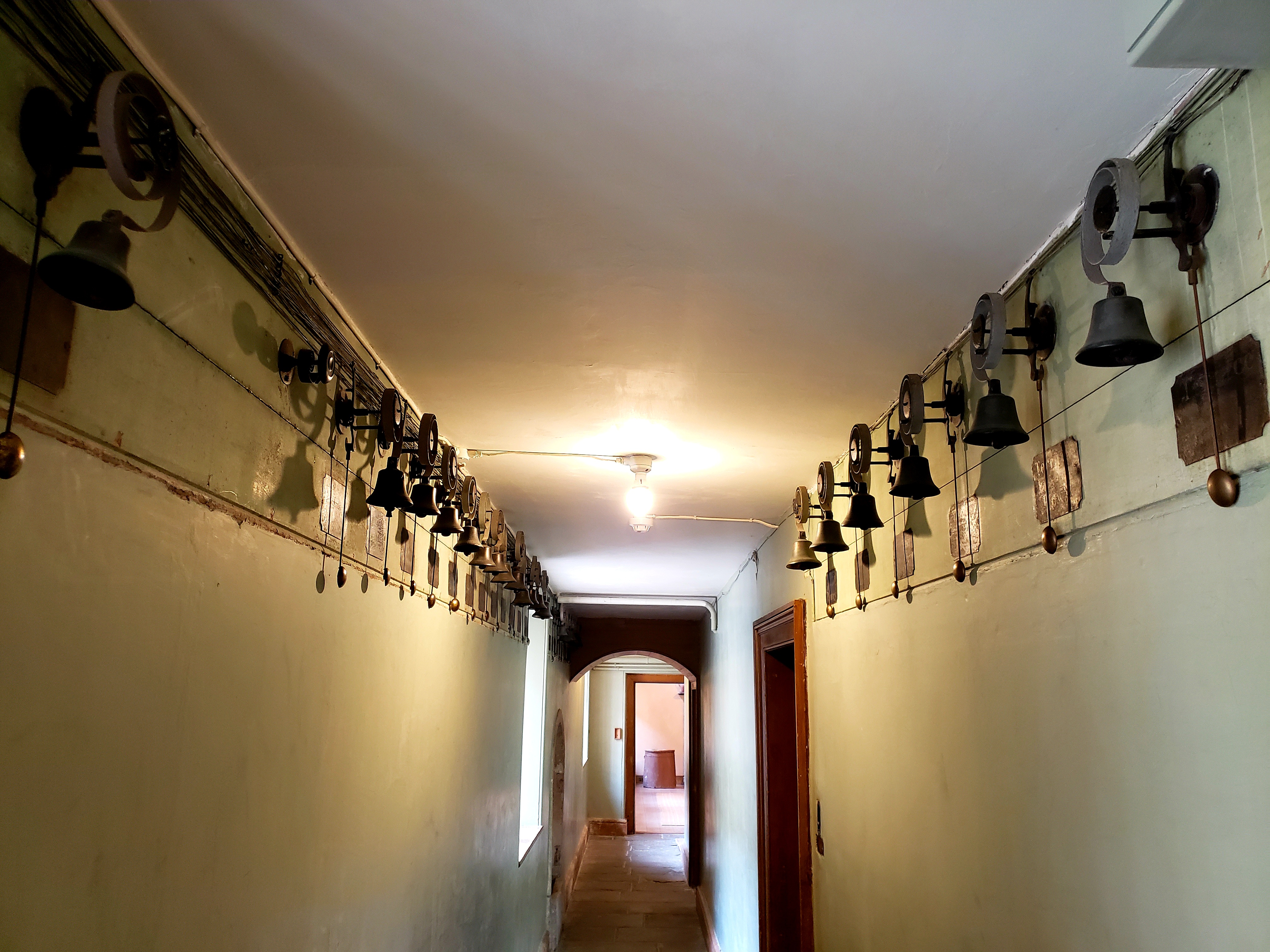 |
| "Bells" Passage |
In late September 2024 I flew to Manchester in the UK. After purchasing a rail card I took the train to Litchfield to explore the town and its lovely unique 3-spired cathedral. After a 2-day stay I headed to Prestatyn, Wales. This is the start point for hikers intending to hike the 177 mile long Offa's Dyke trail from north to south. I planned to hike only the northern half of the trail from Prestatyn to Knighton, a distance of about 90 miles. The trail closely follow's an earthen dyke ordered built on the border between England and Wales by King Offa in the 8th Century. At this time the Romans had left Britain and the Normans hadn't yet invaded (in 1066) and Britain was controlled by the Anglo-Saxons who were located in several kingdoms, all contesting for dominance and superiority. Offa was the king of the large and powerful kingdom of Mercia which bordered the area that is now Wales, and he ordered that an earthen dyke be built along the border of the two areas in order to keep the Welsh at bay. I can't imagine how many men and how much effort went into the construction of this earthen dyke! When originally built the dyke was 27 meters wide and 8 meters high from the bottom of a ditch (on the Wales side) to the top of the bank. Offa's Dyke path roughly follows the location of the original dyke. Because it was earthen, most of the dyke is no longer visible on the landscape, but in some places you can see the ditch or remains of the dyke. The next day after arriving in Prestatyn I started hiking 13 miles to my first destination, the town of Bodfari. The day was a beautiful one for hiking. I crossed lots of stiles and saw beautiful landscapes of the Northern Wales countryside. Hiking the next day from Moel-Y-Parc to Bwlch Penbarra, an 8 mile hike, was both scenically spectacular but strenuous as I had to ascend and then descend 3 high hills - Pen-Y-Cloddiau, Moel Arthur, and Moel Famau -- as I hiked through the Clwydian Hills. Many of the high hills in this region (called "Moels" in Welsh) were the location of Iron Age hill forts, about 30 in number. The rest of the hike was characterized by views of lovely landscapes, several bouts of heavy rain, and one unexpected fall on wet cobblestones on day 8, which resulted in an injury which restricted my ability to walk long distances, but I eventually made it to my intended final destination, the town of Knighton. Some of the highlights of the rest of the hike included: Exploring Castell Dinas Bran, a medieval fortress built in 1260 located on a hill above Llangolen, seeing Plas Newydd (the home of the famous Ladies of Llangolen), hiking on the towpath of the Llangolen Canal from Llangolen to Trefonen, walking across the Pontcysyllte Aqueduct spanning the River Dee, visiting Chirk Castle, walking along the towpath of the Montgomery Canal from Llanmynech to Moors Farm (my favorite accomodation on the trip), spending much of a day exploring Powys Castle in Welshpool and seeing the centuries-old yew trees pruned and sculpted into wonderful topiary, and exploring the ruins of Montgomery Castle.
 |
| Wooden stile |
 |
| Stone stile |
 |
| Curious sheep at another stone stile |
 |
| Welsh countryside on route to Bodfari |
 |
| Crossing the Clwydian Hills |
 |
| Approaching Moel Arthur on Day 2 of hike |
 |
| Castell Dinas Bran outside Llangolen |
 |
| Plas Newydd in Llangolen |
 |
| Towpath of the Llangolen Canal |
 |
| Pontcysyllte Aqueduct over the River Dee |
 |
| Countryside on the approach to Chirk |
 |
| Hiking on the towpath of the Montgomery Canal |
 |
| Montgomery Canal |
 |
| Swans on the Montgomery Canal |
 |
| Powys Castle, made of startling pink sandstone |
 |
| Centuries old pruned yew hedges at Powys Castle |
 |
| Countryside on the way to Montgomery |
 |
| At the ruins of Montgomery Castle |
 |
| Montgomery Castle |
 |
| View from Montgomery Castle |
 |
| Sign at Offa's Dyke trail enters Knighton |
