
After arriving at Heathrow I activated my Britrail Flexipass and travelled to Redhill in Surrey. Once checked into my B & B I contacted my friend Dorothy and that evening we travelled to the nearby village of Horley where we dined at Ye Olde Six Bells pub, reportedly the oldest pub in England.


During my 4-night stay in Redhill Dorothy and I saw a wonderful performance of "War Horse" in London. One day we travelled to three different villages in Kent: Sissinghurst, Cranbrook, and Goudhurst. On another mild and sunny day we visited Hever Castle, the legendary home of Anne Boleyn, the second wife of King Henry VIII, who fell head over heels for the king and lost her head in the process. We toured the interior of the castle then spent much of the day exploring the grounds and lovely gardens.


On touring the grounds I couldn't help but be impressed by the topiary. From the second floor of the castle, which had rooms with portraits of Anne Boleyn and other family members, I was able to look out a window and snap a photo of one of the most fantastical and whimsical bits of topiary -- a series of shrubs that had been intricately pruned to resemble a full chess set.


Leaving Redhill in Southern England I travelled North by train to Newcastle, then got another train to Corbridge. It was in Corbridge that I began my hike of Hadrian's Wall. After checking into my B & B I walked into Corbridge to explore the town. I visited a Greengrocer's to buy apples and a deli to buy bread, cheese and yogurt. After puchasing a sandwich at a shop I sat on a bench outside the church and chatted with some of the locals who were enjoying the sunny and warm weather. Corbridge is a lovely town with an interesting history, built at the location of what was the ancient Roman town of Corstopitum, one of several Roman towns once located along the wall.

The following morning I got up early and had a full English breakfast in preparation for my hike. I was working with an adventure company called Mac's Adventures. They had made all the reservations for the 6 B & B's that would be my lodging for my 5-day hike. They also provided a delivery service which picked up my luggage by 9 am and delivered it to the next B & B where I would be spending the next night and where my luggage was awaiting me when I arrived. By using this delivery service all I had to take on the hike was a small daypack which contained some food, water, and other gear I might need for the day's hike. As I got out of bed and prepared to go down to breakfast I moved my body in just the wrong way and felt a sharp spasm of pain in my lower back, my anatomical weak link. I feared that my back might give me some problems during the hike, but I hadn't expected to experience problems before I even started! The owner of Fellcroft B & B was sympathetic to my situation and during breakfast brought me a vial of pain pills to take with me as I started out on my hike. Corbridge is located about 2 miles South of Hadrian's Wall Path so it took me over an hour to reach the path. The day was overcast and mild and as I walked the pains in my lower back eased.
Julius Ceasar first invaded Brittania in 55 BC but achieved little success. It was the 4th Roman emperor Claudius, in 43 AD, who more successfully invaded with a large force of 40,000 men. The Romans made successive invasions. Some were successful in expanding their occupation, but there were also terrible set-backs, such as in 60 AD when an amazing woman warrior by the name of Boudicca (Boadicea), led a revolt in which thousands of Romans were massacred.
When Trajan became emperor in initiated a line of fortification in the area that is now the border between England and Scotland. The line consisted of forts and watchtowers. Trajan's successor was the emperor Hadrian who ruled as emperor from AD 117-138. Hadrian embarked on a series of travels in order to see firsthand the extent of the Roman Empire. He travelled to Britain in AD 122 and witnessed the extent of the empire in Britain and the difficulties of subduing the tribes of Caledonia, which is now present-day Scotland. Hadrian seemed more interested in stabilizing and maintaining the currently existing empire than in further conquest and expansion. He made an eventful decision. Build a defensive wall along the length of England to keep the unruly Caledonian tribes (e.g. the Picts) out of the empire and to control their movements across the line. It took three Roman legions, a total of 18,000 trained soldiers, only 6 years to construct a wall that stretched the width of Britain, a distance of 73 miles. The wall was approximately 14-20 feet high and 10 feet thick -- and much of it is still in existence today. There is now a footpath that follows Hadrian's Wall, now a National Trail, and thousands of hikers from around the world make the trek each year. Approximately 14% of these hikers are Americans. Not only did the Romans build an imposing wall! At each mile they built a fortified gateway, a milecastle. Evenly spaced between the milecastles they built two turrets or observation posts, a total of 161 turrets in all. They also built a total of 16 forts along the wall, each fort large enough to house from 500-1000 soldiers. To the South of the wall the Romans constructed a deep and wide ditch called a vallum, which flanked by two high mounds of earth; and to the North of the wall they made a deep, wide ditch called a wall ditch.
My plan was to hike along approximately 48 miles of the central portion of the wall from Corbridge in the West to the large city of Carlisle in the East, the section of the hike usually called the "best of the wall". In addition to the hike on the path I would need to leave the path to reach my B & B lodging each night. When I totalled the distances from the wall to my B & B for each of the 5 nights and then back again the following morning I added another 7 miles of hiking to my total mileage.
As I started my hike along the path heading West from Corbridge I saw no evidence of the wall. But it was apparent that I was following the location of the original Roman wall because the remains of the wall ditch was visible, even though the wall was no longer in evidence. Finally, after a while I came across the first bit of the actual original Roman Wall, a 50 yard section of isolated wall located in a section of pasture.


Continuing to hike I began to see, in addition to the wall itself, other evidences of the Roman occupation, such as the base of the Brunton Turret and the remains of Chester's Fort at Chollerford, where the Roman Wall crossed the River Tyne.


On Day 2 I hiked from my B & B in Humshaugh to Vallum Lodge in Once Brewed. It was a long and difficult day. The morning went well as there was good weather, overcast with occasional sun. But then the sky darkened and I was soon battling fierce winds and bouts of driving rain. By the time I reached Once Brewed after 8 hours of hiking my thighs and calves were cramping, and when I removed my boots and socks I discovered that the entire nail on the second toe of my right foot had nearly disengaged from the underlying skin. However, the discomfort from the rain and fighting the brutal winds high up on the crags was balanced by the gorgeous scenery and the fact that I was now following long stretchs of intact wall.
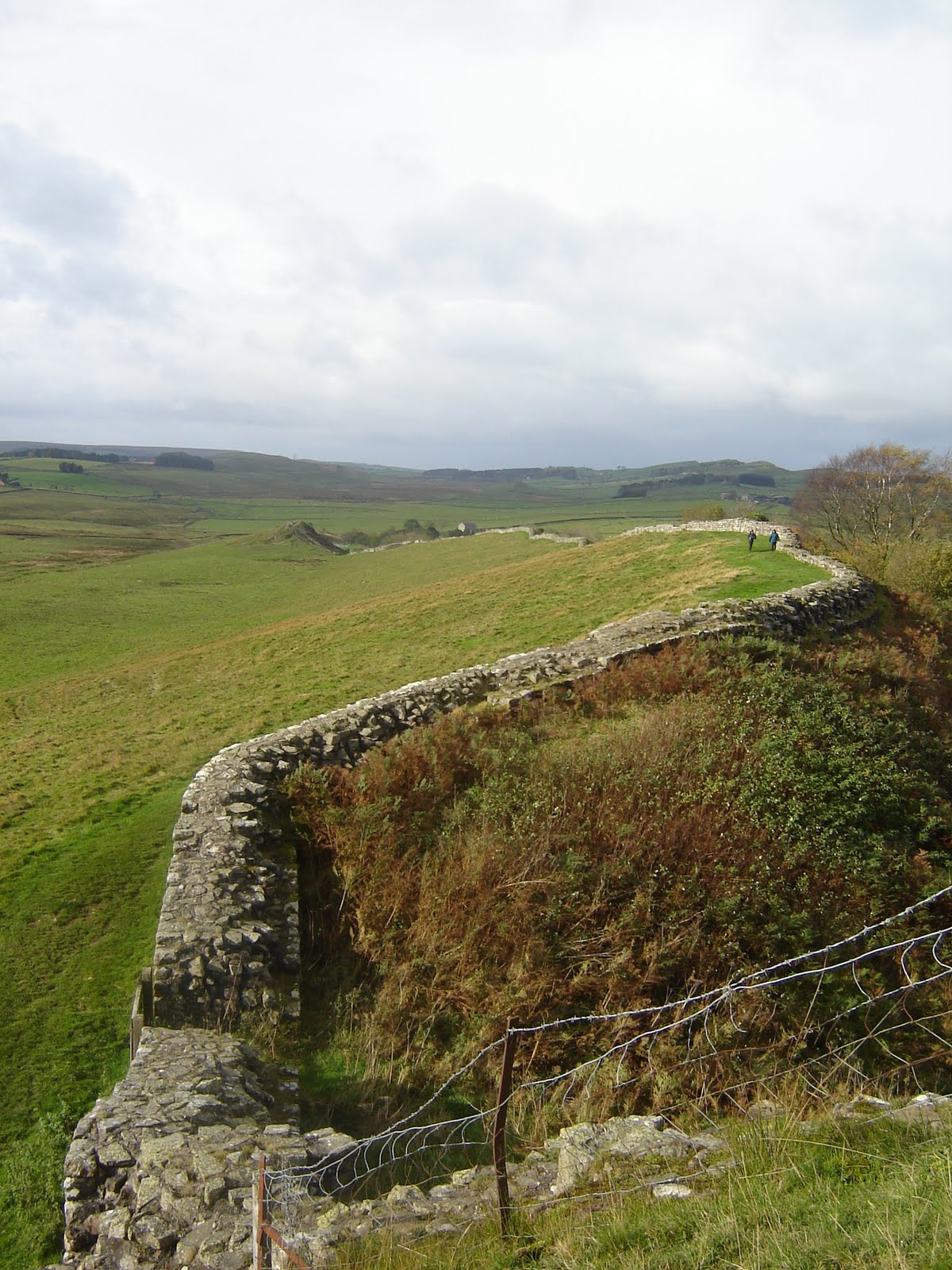
High on the crags near Bromlee Lough I had panoramic views of the countryside and there were well preserved sections of wall as I approached the ruins of the large Roman fort at Housesteads, built in 122 AD, one of the first forts the Romans built along the wall.


Hiking westward from the Roman fort of Housesteads I followed long unbroken stretchs of wall, winding across the countryside like some gigantic serpent.

On Day 3 I hiked from Once Brewed to Gilsland. For those seeking solitude October is a good time to hike Hadrians Wall, as during the entire 5-day hike I encountered fewer than a dozen hikers who were hiking the entire wall. On Day 4 I hiked from Gilsland to Brampton. Leaving Gilsland I encountered the ruins of the original Roman bridge over the River Irthing, and shortly afterwards crossed the present-day bridge over the same river.


Hiking further Westward I eventually left Northumberland and entered Cumbria. The landscape became flatter with more trees, less rugged and desolate, there were more cows and fewer sheep. When I reached Birdoswald Fort, one of the best preserved of the 16 forts along the wall, I finally encountered two fellow hikers, and was able to get my picture taken next to a section of Wall.

That evening I checked into the Oakwood Park Hotel outside Brampton. The following morning, beginning my hike with a bit of frost on the ground, I walked across the farmland of the Cumbrian countryside, seeing no remains of the wall. When I got to the little town of Crosby-on-Eden the path followed along the banks of the Eden River which led me the Carlisle, the last stop on my hike. Before checking into my B and B I visited several locations in Carlisle (e.g. train station, ATM, McDonald's, public library, park bench to rest) and at one of those locations I walked off without my trusty hiking pole which had been so useful in negotiating the hilly terrain on the hike. The next morning I walked to the rail station and took a train from Carlisle to Liskeard in Cornwall, a 9 hour journey. At Liskeard I was met by my 3rd cousin Karen. We chatted and got to know one another better over dinner at her home, and then she took me to Tremaine Farm, the B & B where I stayed for 4 nights during my time in Cornwall. The following morning she picked me up at Tremaine Farm and we drove to Tintagel on the North Cornish coast, where we explored the ruins of the castle there -- as legend would have it the supposed location of King Arthur's court -- and enjoyed the spectacular Cornish coastline.


During our time together Karen did a lot of driving to/from my B & B to fetch me each morning and return me each evening. The day after our trip to Tintagel we spent much of the day at Lanhydrock House, one of the most magnificent estates in all or Cornwall, and now part of the National Trust. On the next day, a very gloomy and rainy one, we spent most of our time inside the giant biodomes of the Eden Project, the largest greenhouse in the world. On my 4th day in Cornwall Karen and I had "just one more cup of tea" together and then I was on the train heading back to London. I stopped for half a day in Chippenham where my friend Clive met me at the train station. Together we visited Bowood House, another large estate with a magnificent house and spacious gardens and grounds. It was in Bowood House that James Priestly, working as a tutor for the owners children, discovered oxygen. Clive and I toured the house, walked parts of the estate, then sat by the pavilion and observed the house from a distance across the lake.
